Basic Information
San Francisco, officially the City and County of San Francisco, is the leading financial and cultural center of Northern California and the San Francisco Bay Area.
The only consolidated city-county in California, San Francisco encompasses a land area of about 46.9 square miles (121 km2) on the northern end of the San Francisco Peninsula, giving it a density of about 17,179 people per square mile (6,632 people per km2). It is the most densely settled large city (population greater than 200,000) in the state of California and the second-most densely populated major city in the United States after New York City. San Francisco is the fourth most populous city in California, after Los Angeles, San Diego and San Jose, and the 14th most populous city in the United States—with a population of 805,235 as of the 2010 Census. The city is also the financial and cultural hub of the larger San Jose-San Francisco-Oakland metropolitan area, with a population of 7.6 million.
Sources:
http://en.wikipedia.org/wiki/San_Francisco
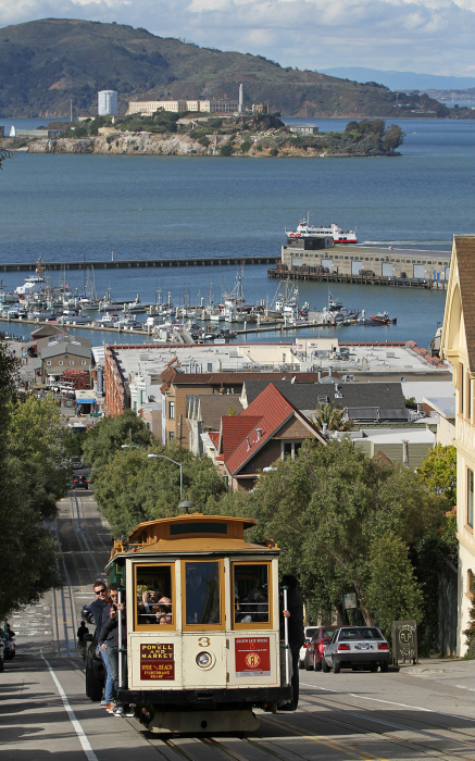
GeographySan Francisco is located on the West Coast of the United States at the north end of the San Francisco Peninsula and includes significant stretches of the Pacific Ocean and San Francisco Bay within its boundaries. San Francisco is famous for its hills. There are more than 50 hills within city limits. San Francisco's tallest hill, Mount Davidson, is 925 feet (282 m) high and is capped with a 103-foot (31 m) tall cross built in 1934.
The nearby San Andreas and Hayward Faults are responsible for much earthquake activity, although neither physically passes through the city itself. The San Andreas Fault caused the earthquakes in 1906 and 1989. Minor earthquakes occur on a regular basis. The threat of major earthquakes plays a large role in the city's infrastructure development. The city constructed an auxiliary water supply system and has repeatedly upgraded its building codes, requiring retrofits for older buildings and higher engineering standards for new construction. However, there are still thousands of smaller buildings that remain vulnerable to quake damage. San Francisco's shoreline has grown beyond its natural limits. Entire neighborhoods such as the Marina, Mission Bay, and Hunters Point, as well as large sections of the Embarcadero, sit on areas of landfill. Treasure Island was constructed from material dredged from the bay as well as material resulting from tunneling through Yerba Buena Island during the construction of the Bay Bridge. Such land tends to be unstable during earthquakes; the resultant liquefaction causes extensive damage to property built upon it, as was evidenced in the Marina district during the 1989 Loma Prieta earthquake. Most of the city's natural watercourses, such as Islais Creek and Mission Creek, have been culverted and built over, although the Public Utilities Commission is studying proposals to daylight or restore some creeks. Source: http://en.wikipedia.org/wiki/San_Francisco#Geography |
Retrieved from http://en.wikipedia.org/wiki/User:Jjron
|
Climate
A popular quote incorrectly attributed to Mark Twain is "The coldest winter I ever spent was a summer in San Francisco". San Francisco's climate is characteristic of the cool-summer Mediterranean climate of California’s coast, "generally characterized by moist mild winters and dry summers". Since it is surrounded on three sides by water, San Francisco's weather is strongly influenced by the cool currents of the Pacific Ocean, which moderate temperature swings and produce a remarkably mild year-round climate with little seasonal temperature variation.
Among major U.S. cities, San Francisco has the coldest daily mean, maximum, and minimum temperatures for June, July, and August. During the summer, rising hot air in California's interior valleys creates a low pressure area that draws winds from the North Pacific High through the Golden Gate, which creates the city's characteristic cool winds and fog. The fog is less pronounced in eastern neighborhoods and during the late summer and early fall, which is the warmest time of the year.
Because of its sharp topography and maritime influences, San Francisco exhibits a multitude of distinct microclimates. The high hills in the geographic center of the city are responsible for a 20% variance in annual rainfall between different parts of the city. They also protect neighborhoods directly to their east from the foggy and sometimes very cold and windy conditions experienced in the Sunset District; for those who live on the eastern side of the city, San Francisco is sunnier, with an average of 260 clear days, and only 105 cloudy days per year.
Sources:
http://en.wikipedia.org/wiki/San_Francisco#Climate
Retrieved from http://en.wikipedia.org/wiki/User:Jjron
|
TransportationFreeways and roads:Due to its unique geography, and the freeway revolts of the late 1950s, San Francisco is one of the few American cities with arterial thoroughfares instead of having numerous highways within the city.
Public transportation: 32% of San Francisco residents use public transportation in daily commuting to work, ranking it first on the West Coast and third overall in the United States. -San Francisco Municipal Railway, aka Muni -Bay Area Rapid Transit Cycling is a popular mode of transportation in San Francisco. 75,000 residents commute by bicycle per day. Pedestrian traffic is a major mode of transport. In 2011, Walk Score ranked San Francisco the second most walkable city in the United States Airports: -San Francisco International Airport -Oakland International Airport Port of San Francisco Sources: http://en.wikipedia.org/wiki/San_Francisco#Transportation |